This chapter reviews international major practices for promoting compact and connected development in OECD regions and cities. It begins by exploring the importance of compact and connected urban development, then examines six international case studies in greater detail, highlighting key lessons for Korea from each example.
Enhancing Compactness, Connectivity and Accessibility in Korea

Abstract
Korea is currently facing a range of urban development challenges, including urban sprawl, an ageing and shrinking population, overconcentration, and the expansion of large cities into metropolitan areas. This expansion has often been accompanied by population moving to surrounding areas, but with limited transport connectivity. These trends highlight the need for a more compact and connected model of urban development. A key challenge is to ensure that all residents, including those living in the peripheries of cities, have access to urban opportunities and employment. Over the past two decades, several countries and cities have reformed their transport policies and undertaken infrastructure investment projects aimed at improving accessibility, defined as the ease with which people can reach destinations and connect with others (Rode et al., 2014[1]). The experiences of OECD countries that have successfully promoted compact and connected urban development may offer valuable lessons for Korea.
The advantages of promoting a compact and connected urban growth
Reshaping cities to be compact and connected will not only make them more accessible, but also more liveable, resilient and sustainable. One of the key lessons from the COVID-19 pandemic was the need for mixed-use urban districts where people of all incomes and social statuses can live, work and access urban opportunities without traveling long distances (OECD, 2020[2]). In many cities around the world, residents have found that their housing does not meet their needs, and that few services or amenities are available within walking distance. Research suggests that investments aimed at making cities more accessible without relying on private vehicles have the potential to reduce greenhouse gas (GHG) emissions, enhance quality of life, and improve communities’ resilience to future crises (Rode et al., 2021[3]). For Korea, as for many other countries, there are multiple advantages to focusing on compact and connected urban development policies. Such an approach could yield significant benefits within the current urban context, such as:
Improve the quality of the urban built environment. The built environment is a crucial aspect of urban space and plays a key role in a city's sustainable development. This is because it is closely linked to a wide range of human wellbeing factors, including public health, climate change, safety, accessibility, physical activity, sustainability, and social equity. The recent global pandemic demonstrated that density alone did not increase vulnerability to COVID-19; rather, it was the structural economic and social conditions of cities that shaped their resilience, influencing the effectiveness of policy responses (OECD, 2020[2]). Compact and connected development requires increased density and the creation of diverse population spaces to support smart growth and environmental sustainability (Huang et al., 2024[4]). This includes regenerating older urban areas to enhance walkability and stimulate economic revitalisation. However, high-density and mixed-use development can, in some cases, inhibit social interaction and trust, potentially undermining community cohesion and reducing the use of public spaces by older adults and children.
Revitalise public transport. Compact and connected urban development plays a vital role in shaping more efficient and sustainable urban structures. It supports increased public transport use, makes walking and cycling safer and more convenient, and discourages reliance on private vehicles. Transport policy is one of the three essential domains, alongside spatial planning and social policy, that must be considered when promoting urban accessibility (Rode et al., 2019[5]). Revitalising public transport requires strong cross-sector collaboration and governance reforms to support more integrated urban planning and policymaking.
Enhance access to public services. Compact and connected cities are in a better position to provide access to public services due to the physical proximity between places of residence and key destinations. The objective is not only to facilitate efficient movement but also to ensure people can access the services, goods, and social connections they need. A more compact and connected urban model can improve access to healthcare, education, leisure, and cultural services, promoting a more inclusive form of development.
Improve support for start-ups and the local economy. A compact and connected urban environment can help strengthen the local economy by supporting the growth of start-ups and small businesses. Cities have the opportunity to create incubation spaces and establish local accelerator programmes to nurture entrepreneurship. Furthermore, such environments can encourage local industry clustering, where businesses in the same sector collaborate and innovate, contributing to economic vitality.
Support community building. Compact and connected development may foster social cohesion, diversity, and civic participation. By creating environments that encourage interaction and collaboration, cities can enable stronger community ties and increase opportunities for residents to engage in civic life.
Promote collaborative governance. Policies supporting compact and connected development play a critical role in enabling the active participation of a wide range of stakeholders, including residents, businesses, civil society organisations, and public authorities, in urban decision-making. This approach facilitates participatory planning, co-creation, community empowerment, and public-private partnerships. Collaborative governance can enhance stakeholder involvement, ownership, and accountability in urban planning and management. It also helps address challenges associated with compact development, such as gentrification, displacement, inequality, and social exclusion.
Improving the quality of urban built-environment through transport-oriented development: the case of New South Wales (Australia)
Australian cities are at an inflection point in their urban development trajectory. Until recently, living in flats was a preference held by a minority. While owning a detached suburban home on a plot of land remains the aspirational ideal for many Australians, this is gradually shifting under the current metropolitan planning approach. Building more compact and connected cities, with higher densities, is slowly becoming the new urban norm in Australia. This shift is already visible on the suburban fringe, where lot sizes are shrinking, and subdivisions are becoming more densely populated. Today, higher-density housing—delivered primarily through urban renewal and infill development—is expected to be the main driver of residential growth in cities across New South Wales (NSW), as well as in other major Australian urban areas. This change is driven by the need to accommodate a growing population of smaller and older households, alongside efforts to contain urban sprawl. However, car commuting remains the predominant mode of transport.
In 2023, the NSW Government identified housing provision as a top priority in response to a critical housing shortage. To address this, the government introduced a Transport-Oriented Development (TOD) programme (NSW Government, 2023[6]). The core objective of the programme is to build more well-located homes close to public transport, employment opportunities, and essential services. The TOD programme consists of two main components:
Part 1 focuses on eight ‘accelerated precincts’ to create infrastructure and capacity for 47 800 new homes over 15 years. This includes land within 1 200 metres of eight rail and metro stations, which will be rezoned by the NSW government to allow for increased housing density and the provision of more affordable homes.
Part 2 targets precincts that already possess existing infrastructure and are located within 400 metres of 31 train and metro stations. These areas are projected to support an additional 138 000 homes over 15 years. Planning reforms under a new State Environmental Planning Policy (SEPP) are expected to accelerate the delivery of housing near jobs and amenities.
The NSW Government’s goal is to deliver more high-quality, well-located homes near public transport, community services, and open spaces. The focus is on placing housing close to both planned and existing transport infrastructure, which is anticipated to reshape urban development patterns by curbing further sprawl (NSW Government, 2023[6]). This approach also responds to renewed public demand for accessible neighbourhoods in the wake of the COVID-19 pandemic, where proximity to shops, restaurants, parks, and public transport is increasingly valued. Although transport-oriented development has long been a feature of strategic planning in NSW, this new TOD initiative represents a reinvigoration of the concept in support of more compact and connected urban growth. For instance, in 2024, authorities in the Hornsby district launched a community consultation on a rezoning proposal under the eight TOD-accelerated precincts scheme. Hornsby, located in Greater Sydney, is a high-growth area near major transport hubs (Figure 3.1). The proposal is expected to create capacity for over 6 000 new homes, 2 900 new jobs, and include affordable housing contributions of 3% to 10% for all new residential developments within the precinct. It also envisions greener streets, improved walking and cycling connectivity, and new or upgraded parks and open spaces.

Source: NSW Government, Hornsby TOD rezoning, at: https://www.planning.nsw.gov.au/plans-for-your-area/priority-growth-areas-and-precincts/hornsby; accessed on 21 February 2025.
Through its TOD programme, the NSW Government aims to not only increase the capacity for well-located housing near jobs and urban opportunities, but also improve access to transport and essential services for residents. The initiative is expected to deliver new metro stations, walkable neighbourhoods, a diverse mix of housing options, expanded public open spaces, a vibrant nightlife, and various other amenities. These improvements are intended to ease financial pressures on households and reduce traffic congestion, thus enhancing overall quality of life. Moreover, over the next 15 years, the NSW Government plans to deliver more than 150 000 new homes in mid-rise buildings, including affordable housing, within close proximity to TOD stations. To support this goal, the government has mandated a minimum of 2% affordable housing in all new developments across 37 targeted locations.1 This percentage will gradually increase over time to ensure that essential workers, particularly in healthcare and education, can live closer to their places of work.
To facilitate the implementation of the TOD programme, the NSW Government has introduced a new State Significant Development (SSD) assessment pathway. An SSD is defined as a development that holds economic, environmental, or social importance for the state (NSW Government, 2024[7]). Projects may be declared as SSDs either through a State Environmental Planning Policy (SEPP) or by ministerial order. The government is working to expedite the SSD approval process, targeting a maximum processing time of 90 days to accelerate housing delivery.
An important component of the TOD strategy is the promotion of vibrant and diverse local entertainment zones, particularly aimed at younger residents (NSW Government, 2023[6]). The Special Entertainment Precinct (SEP) framework may be applied to up to 39 TOD precincts, subject to local council requests. Special entertainment precincts -defined areas where sound from premises with amplified music is managed by a council through its noise management plan- are intended to support live entertainment through extended trading hours for live music venues and favourable noise controls that provide operational certainty for venues, neighbouring residents and businesses.2 This is expected to provide more variety of activities (leisure and commercial) to mostly young people and avoid commuting to other places. Councils can implement SEPs by adopting guidelines for amplified music and preparing tailored plans to encourage more live performance venues, creating safe and vibrant ‘going-out’ destinations supported by reliable public transport.
For each of the eight accelerated precincts selected, the NSW Government is developing a comprehensive master plan, supported by technical studies. These plans will identify opportunities for additional housing within 1 200 metres of the associated transport stations (NSW Government, 2023[6]). Collaboration with local councils is essential, as planning controls must deliver outcomes that reflect the unique character and needs of each location. Strategic plans must address several key elements, including: i) the use of appropriate planning controls and zoning to reflect medium-to-high-density development potential; ii) a long-term residential supply pipeline to ensure sustained growth; iii) affordable housing provisions secured in perpetuity; and iv) amenity outcomes, such as access to public open space and community services.
What lessons for Korea?
The experience of New South Wales (NSW) offers several relevant lessons for Korea as it seeks to implement more compact and connected urban development. Five key takeaways stand out:
Planning TOD around affordable and diverse housing tenures. The NSW case underscores the importance of ensuring that transport-oriented development includes affordable housing options and diverse forms of tenure. Affordable housing near transport hubs is essential for low-income households and older residents, as it helps reduce transport costs and enhances mobility. Mixed-income TOD projects ensure broader access to genuinely affordable housing—an issue Korean cities continue to face (OECD, 2018[8]). TODs often become unaffordable due to high demand, pushing out lower-income residents. Ensuring income diversity within these developments helps prevent exclusion, enhances access to jobs and essential services, and mitigates the risk of gentrification.
Focusing on accessibility, not just mobility. NSW highlights the need to move beyond simply enabling movement, to achieving genuine accessibility. This involves the physical concentration of people, services, and economic activities. Key characteristics of successful TODs include residential and workplace density, functional diversity, degrees of land-use mixing, centralisation, and high-quality local urban design. These features support more efficient and inclusive access to opportunities.
Recognising that accessibility depends on intensive land use. Accessibility is influenced not only by proximity but also by how different resources are arranged within an area—particularly around transport nodes like metro stations. It also depends on transport availability, the timing of accessible opportunities, and residents’ varying needs and abilities. The NSW experience shows that achieving accessibility often requires trade-offs between these factors. For Korea, it is essential to design TODs with high land-use intensity while balancing competing priorities.
Integrating leisure spaces into TOD areas. The inclusion of leisure and recreational spaces in TOD precincts is vital for retaining younger populations, especially in regional hub cities in Korea where such amenities are often lacking. The NSW case illustrates the value of integrating leisure planning into the strategic development of TODs. Doing so strengthens social cohesion and stimulates the local economy. Strategic coordination with a wide range of stakeholders is needed to ensure TOD areas are both peaceful for residents and dynamic for business and leisure.
Emphasising flexible planning and long-term investment. The NSW model stresses that each TOD precinct must be planned according to its unique characteristics, needs, and constraints. Korean planners can benefit from incorporating foresight exercises to anticipate the long-term evolution of TOD areas. Such an approach enables more adaptable planning and allows for responsive updates to development strategies as urban conditions change.
Improving the quality of service around stations: the case of the Grand Paris – station-led TOD in the Île-de-France region (France)
Île-de-France provides a compelling example of a metropolitan region where urban functions are increasingly dispersed across both urban and rural areas, thanks to a highly developed transport infrastructure and the influence of the information society. As the most populous of France’s 18 administrative regions, Île-de-France had over 12 million inhabitants in 2023. It comprises eight departments: Paris, Hauts-de-Seine, Seine-Saint-Denis, Val-de-Marne, Seine-et-Marne, Yvelines, Essonne, and Val-d'Oise. The region contains 1 281 municipalities and is governed by the Regional Council, the deliberative assembly responsible for regional policy and planning.
In 2011, the regional government, with support from the national government, approved the Grand Paris Express (GPE) project, a 200-kilometre expansion of the metro system designed to connect nearly all suburbs within Île-de-France. Crucially, the new lines are planned to link major residential and business districts in the suburbs without passing through central Paris (Figure 3.2).
While the city of Paris, home to approximately 2 million people, already benefits from excellent public transport services, the surrounding suburban areas, with over 10 million inhabitants, remain poorly connected to one another. The GPE aims to address this imbalance by: facilitating easier travel between suburban areas; improving access to previously underserved locations; reducing social inequalities; restructuring regional mobility; and stimulating the development of station areas and contributing to the overall transformation of the Paris region. The project also intends to alleviate congestion on the suburban rail network (Réseau Express Régional, RER) and reduce car traffic by offering more direct and efficient transit routes.3 The GPE is projected to deliver substantial economic and social benefits. Estimates suggest it could increase the region’s GDP by over EUR100 billion, create 115 000 jobs over 25 years, and generate social and economic gains worth nearly EUR80 billion (Christeller, 2020[9]). The network will be rolled out in phases, with sections entering service between 2024 and 2030.4 In addition to the transport infrastructure, the project includes plans for the development of between 250 000 and 400 000 new housing units around the 68 new stations, helping to foster compact, accessible, and well-connected urban growth across the metropolitan area (Société du Grand Paris, n.d.[10]).

Source: APUR, at: https://www.apur.org/en/geo-data/observatory-grand-paris-station-neighbourhoods, accessed on 21 February 2025.
The Grand Paris Express (GPE) will involve the construction of a network of 68 stations, requiring coordinated efforts between regional and local governments. These stations are expected to enhance the living environment, act as new urban centres to support balanced regional development, and improve access to jobs, services, businesses, and facilities. As a result, station areas lie at the core of the region’s urban intensification strategy. This includes encouraging higher-density development around the stations and creating more favourable conditions for active mobility, such as walking and cycling. The stations will feature shops, services, and shared public spaces. Depending on the existing commercial offer in each area, both residents and passengers will have access to local products as well as major retail outlets. Regional authorities aim to develop greener and more accessible neighbourhoods where residents, commuters, workers, and students can coexist. Planned real estate developments will include a mix of public housing, rental units, and homes for sale. In addition, student residences and live-work spaces for artists are envisaged. Community centres, shops, and residential hotels will also be developed as they become economically viable, while ground-floor units will be allocated to the non-profit sector.5
Across the entire Grand Paris Express (GPE) network, both the city and its suburbs will be redesigned and densified. One of the key challenges is that the GPE is being implemented within an already established transport system and densely populated urban areas in Île-de-France. This raises important questions about the impact on existing residents and how to maintain or improve their quality of life as population density increases around the station areas. To address this, authorities are focusing on creating sufficient green spaces and enhancing connectivity between major urban parks through landscaped corridors. They also aim to integrate a mix of urban functions within walking distance, improving the quality, scale, and connectivity of public spaces for both pedestrians and cyclists. These efforts are intended to enhance district vitality by supporting local businesses, services, and facilities.
For transit-oriented development (TOD) stations to succeed in Île-de-France, it is essential to balance road use among various transport modes and to reduce the dominance of private cars. This includes increasing the availability of paid parking near stations, reserving park-and-ride facilities for non-residents, and limiting on-street parking to encourage active mobility. To achieve these goals, the various stakeholders involved, such as planning authorities and transport operators, are coordinating mobility projects within a 300-metre radius around each station. They are also considering expanding this approach at both the municipal and intermunicipal levels to ensure efficient feeder services and better continuity for cycling and walking routes.
In Île-de-France, the financing model for the construction of the GPE is based on earmarked taxes, which enable the repayment of the loans undertaken for the project. In France, several taxation mechanisms related to property, real estate transactions, and new construction such as property taxes, transfer duties, and the development tax can be leveraged to fund the GPE. However, the potential impact on the local real estate market remains uncertain, particularly within the limited areas surrounding the new stations. There is a risk that these localised changes could lead to a rigidification of the housing market or even contribute to rising property prices in the vicinity.
The expansion of the metro system to the outer suburbs of the capital is also expected to influence the growth and profitability of real estate. Authorities anticipate that the ‘connection effect’, where improved accessibility raises demand, will significantly increase property values in areas near the new stations. Estimates suggest that prices in newly connected suburban locations could rise by 10% to 15%.6 However, the scale of this increase will also depend on the commercial development and the range of businesses that emerge around these hubs, which will determine the extent of capital gains from property investments.
Organising a coherent territorial development project such as the GPE requires integrated governance and effective coordination tools. The delivery of the GPE is overseen by the Société du Grand Paris (SGP), a public body established by the French government specifically for this purpose. The SGP is responsible for the construction of the lines, stations, structures, and related facilities, the procurement of rolling stock, and the development of the station areas and their surroundings. Once operations begin, responsibility for managing the network will be transferred to the Syndicat des Transports d’Île-de-France (STIF), which will invite transport operators to bid for the running of the GPE lines. STIF coordinates the activities of various transport operators, including RATP, SNCF, and private companies. It is a regional public agency accountable to the Region of Île-de-France, the City of Paris, and the seven surrounding administrative departments (Société du Grand Paris, n.d.[10])
The GPE requires the coordination of a wide range of stakeholders, often with differing interests. These include public transport authorities, real estate developers, regional and local governments, and citizens, all of whom must engage in negotiations regarding the transit-oriented development (TOD) around each station. In addition to the links between the transport authority (Île-de-France Mobilités) and its partners in station areas, local administrations include a variety of developers, public organisations, land operators, and private sector actors, many of whom operate outside direct public control. To address this complexity, the French government launched the Committee for the Vitalisation of Station Areas in 2021. This body aims to pool knowledge and resources, share good practices, and address challenges encountered during the implementation of projects led by local and territorial administrations (communes).
What lessons for Korea?
The case of the Grand Paris Express (GPE) is relevant to Korea for six key reasons:
It demonstrates the importance of multi-level governance. The project highlights the need for national, regional, and local governments to work together in designing and implementing a shared, region-wide vision. Effective coordination across levels of government is essential for smooth implementation and sustained long-term support. The case also underscores how urban development is shaped by policies operating at multiple levels. Establishing public bodies tasked with project delivery—accountable to government—can be a decisive factor in ensuring clarity of responsibilities and timely completion in a context with many stakeholders.
It shows how transport stations can be catalysts for urban revitalisation. The GPE illustrates how metro stations can serve multiple functions and support high-density land use. These stations influence patterns of growth, daily activities, commuting behaviour, real estate values, and inclusive economic development. Prioritising development around stations can reduce travel distances and greenhouse gas emissions. Some stations are also designed as intermodal hubs, linking local and long-distance networks. The project further shows how parking policies can help manage traffic and encourage public transport use.
It emphasises the importance of social inclusion in TOD projects. The provision of affordable housing and a diversity of housing tenures around transport nodes is vital to ensuring equitable access to urban amenities. This approach helps prevent gentrification and the displacement of low-income households from areas with good transit access, making land use more inclusive.
It underlines the value of dedicated governance structures. The GPE demonstrates that having a technically capable coordinating body, accountable to government, is crucial for both construction and operational phases, particularly in a metropolitan region with complex administrative fragmentation.
It highlights the role of green spaces in enhancing urban quality of life. Green spaces serve a dual purpose: they support public health by improving air quality and mitigating heatwaves, and they reassure existing residents that increased density does not mean overcrowding. Access to peaceful, natural environments helps to build community support for urban intensification.
Its model of connectivity can be adapted to metropolitan areas of varying sizes. While the scale and capacity of Korean metropolitan areas may differ from that of Île-de-France, the core principles of the GPE—intensified land use around transit stations, improved intra-urban connectivity, facilitation of movement, equitable travel, and inclusive land use—are broadly applicable across metropolitan regions of all sizes.
Managing population decrease and densification through low-cost public transport revitalisation: the case of Toyama City (Japan)
In Japan, Toyama City serves as an example of a compact city that has made significant investments in public transport to address population ageing and decline. By the end of the 20th century, Toyama was experiencing urban sprawl and demographic shifts. Its population density was among the lowest of all prefectural capitals. In 2024, the city had of a population of 407 000 inhabitants7, while in 2015 the number was 418 000 residents, an annual decline of -0.36%. In the early 2000s, the city’s shrinking and ageing population led to a heavy reliance on private cars and a decline in public transport services. Between 1989 and 2009, the number of bus routes was reduced by 40%, and 84% of commuters opted to drive (compared to 72% nationally), rather than using public transport (Mori, 2013[11]). The city centre lost its vitality due to suburban development, resulting in the hollowing out of central areas. These combined trends led to increased administrative and operational costs for managing the transport system, as well as higher greenhouse gas emissions.
In 2002, the city government established the ‘Compact City Development Group’ (CCDG) to explore policy options for addressing the challenges of population decline and ageing.8 To make the city more compact, the CCDG adopted a polycentric approach that linked multiple interconnected small cities and facilities. The strategy consisted of three pillars: i) revitalising public transport; ii) encouraging the relocation of residents and business to zones along public transport corridors, and iii) re-energising the city centre (OECD, 2012[12]). In 2003, the national government adopted the “Compact Plus Network” policy that promoted an integrated approach to urban and transport planning. Toyama City policy was then aligned to the national government’s policy to ensure a smooth implementation.
Toyama City gradually strengthened its public transport network with the use of existing railway lines. This started with the launching of a Light Rail Transit (LRT) line in the northern part of the city in 2006 with strong support from the private sector (Paul et al., 2021[13]; OECD, 2012[12]). By creating the LTR network, the city sought to modify the current lifestyle of overdependence on cars and ensure that all city amenities are located within walking distance from a public transport stop (Figure 3.3). For the LRT project, Toyama City adopted a scheme whereby it prepared the tracks and vehicles, and a private company operated the LRT. In this way, the city injected operational expertise from the private sector into the LRT service. Toyama City had a good understanding of the private sector, had built relationships over time, and had approached the companies as equal partners leading to a strong collaboration. This is reflected in the public-partnership formed to operate the LRT as Toyama City and local companies jointly founded Toyama Light Rail Company, Ltd. This allowed local companies to finance 50% of the budget for the construction of the LRT. The LRT network covers 7.6 kilometres with 13 stations and has an average travel time of 25 minutes from origin to destination. To improve the LRT’s infrastructure, five new stations were added, low carriage floors were introduced, and the stations were made wheelchair accessible. Moreover, the city introduced a preferential fare for the elderly what doubled the ridership during weekdays and an increase of 3.5 times on weekends (Mori, 2013[11]). Since Toyama City had limited resources to construct capital-intensive infrastructure, it had to be innovative in ways to reduce capital expenditure. Therefore, the city decided to use old rail tracks to construct at a lower cost, nearly 75% less than building new tracks, and reduced construction periods (Paul et al., 2021[13]).

Source: Toyama City, at: https://cobenefit.org/good_practice/detail/pdf/ACP_japan-toyama_0526.pdf; accessed on 21 February 2025.
To encourage people to move to the city centre, the city designated a ‘city-centre area’ (approximately 436 hectares) and ‘residence encouragement zone’ (along public transport lines covering an area of approximately 3 000 hectares) (Mori, 2013[11]). The strategy for the creation of a compact city included not only the revitalisation of public transport through the LRT, but the concentration of various functions such as residential, commercial, business and cultural buildings along public transport lines. The city extended the tram line into a loop line to revitalise the city centre by improving mobility. Public subsidies support the development of housing complexes in these areas. The city has also made efforts to make the city centre more attractive and accessible, including the major undertaking of building a public square called ’The Grand Plaza.’ Toyama also launched a bike sharing programme to ease access to the city centre. To concentrate urban functions in the city centre and areas along public transport routes, the city introduced two subsidy systems: i) the City Centre Dwelling Promotion Scheme to subsidised construction companies and citizens who purchase or rent a house in the city centre, and ii) a scheme to promote dwelling along the public transport axes to subsidise construction companies and citizens willing purchase a house in the designated areas with easy access to public transport (OECD, 2012[12]).
Key to the success of Toyama City’s strategy was the governance arrangement supported by a vision and clear objectives. The overarching vision, set by local political leaders, was broken down into clear objectives, which translated the city’s vision into strong organisational commitment and buy-in from key stakeholders including citizens and the private sector. Organisational setup for the development of the LRT system was key to the city’s success.
The reported benefits of the Toyama LRT and the City Loop line include increased ridership, in particular for the elderly, a shift away from motorised vehicle use, an increasingly active elderly population, higher levels of economic activity in the city centre, and reduced GHG emissions. The growth rate of city centre population turned positive in 2008 (Mori, 2013[11]). Since its adoption, Toyama City’s compact management strategy has been creating value in three areas: environment (reduction of CO2 emissions and revitalisation of the city centre); social (improving community healthcare, safety and security, nursing care); and economic (reduction of administrative costs, formation of new industries, increases in tax revenue, promotion of local industries and job creation).9
What lessons for Korea?
Toyama City offers relevant lessons for regional hub cities in Korea today. Five key takeaways emerge:
The importance of an integrated approach to Transit-Oriented Development (TOD). Toyama demonstrates that transport alone cannot transform urban life. An integrated approach, coordinating transport with housing, economic, and social policies, ensures that various measures work together toward a common goal. For instance, subsidies were provided for older adults to use public transport and for residents willing to relocate to central areas or locations along transport corridors. These measures contributed to increased public transport use and higher population density in the city centre. The polycentric urban structure, with multiple hubs connected like skewers, also allows pedestrians to easily access a wide range of amenities.
Leveraging existing assets instead of building new infrastructure. The case highlights the value of optimising existing infrastructure—such as roads and railways—especially in the context of population decline and limited budgets. This approach helps reduce capital expenditures, maximises the value of current assets, and lowers environmental impact by limiting land use. It is particularly relevant for cities facing space constraints. Moreover, defining the physical structure of the city is a vital first step in enabling targeted interventions to address urban challenges and build social capital.
The need for strong, long-term leadership. Effective leadership at all levels is essential for developing and sustaining a clear vision. This vision must translate into strong organisational commitment to successfully implement city-wide initiatives. Long-term leadership ensures consistency, stability, and momentum in urban development efforts.
Effective governance and coordination with national governments. Proper governance structures are critical to the timely delivery of infrastructure projects such as the Light Rail Transit (LRT) system. In Toyama’s case, strong coordination prevented potential losses in economic value and helped maintain public trust. Working closely with the national government is also crucial, not only for securing essential funding, but for aligning local projects with national priorities, such as managing an ageing population and promoting compact urban development.
City centre revitalisation as a core component of TOD. Toyama’s experience underscores the importance of including city centre renewal in the TOD vision. City centres offer prime opportunities for dense, walkable, mixed-use development with close proximity to services. These areas already benefit from existing infrastructure, municipal services, and transit access, making their revitalisation more efficient and sustainable than expanding into undeveloped areas. Revitalising the city centre also supports the creation of complete neighbourhoods that offer diverse amenities, promote social inclusion, and reduce travel needs by bringing services closer to residents.
Building transport-oriented communities: the case of Metro Vancouver (Canada)
The Metro Vancouver Region (MVR)-or Greater Vancouver- in British Columbia (B.C. , Canada, is a partnership of 21 municipalities, one Electoral Area and one Treaty First Nation. The MVR is Canada’s third-largest metro region, in terms of population and economic activity, behind Toronto and Montreal. In 2021, the MVR had a population of 2.6 million inhabitants of which 662 200 lived in the city of Vancouver.10
MVR faces challenges that hinder its socio-economic performance such as: i) historical underinvestment in public transit and road infrastructure; ii) poor housing affordability; iii) land scarcity for port expansion; and iv) low labour productivity levels, among others. Much of the metropolitan area is characterised by low density, single family housing with regional or town centres acting as nodal and commercial focal points (Krawchenko, 2012[14]). Poor housing affordability limits Vancouver’s attractiveness to highly skilled workers.
To tackle urban challenges and improve the region’s prosperity prospects, the regional planning authority adopted a transit-oriented community (TOC) approach, which is understood as “…places that take access to and support for transit into account when planning and designing at a neighbourhood, corridor, municipal, or regional scale” (TransLink, 2012, p. 2[15]). A transit-oriented development (TOD) is a project site shaped by its close proximity to rapid transit. TOCs are intended to foster an improved urban environment with safe and enjoyable places to walk, cycle, and spend time outdoors for people of all ages and abilities, facilitating walking and cycling and supporting healthy lifestyles. Creating TOCs requires the active participation of a broad range of public and private stakeholders. The TOD areas could expand beyond the limits of administrative areas. For example, as shown in Figure 3.4, the TOD around the Inlet Centre station area covers the City of Port Moody and the City of Coquitlam within the MVR. Metro Vancouver’s Regional Growth Strategy and the Regional Transport Strategy ensures such planning co-ordination across municipalities. Their approach to land use is to locate high-density, mixed-use development within walking distance from frequent transit services. The area around transit stations typically incorporate residential and commercial uses, and community amenities. The core principle of this approach is to build more homes near transit and for services to build complete, liveable and sustainable communities.

Source: British Columbia, Transit oriented development areas, at: https://www2.gov.bc.ca/assets/gov/housing-and-tenancy/tools-for-government/local-governments-and-housing/maps/port_moody__coquitlam_inlet_centre_station_toa_map_day_1.pdf; accessed on 21 February 2025.
The regional planning authority aims to improve mobility and accessibility in the region via transport investments. The MVR aims to build walkable, mixed-use, and transit-oriented communities where people can work, access services, live and enjoy social, cultural, educational and recreational pursuits. Providing diverse and affordable housing choices to meet current and future demand is a key objective of this strategy. For regional planning authorities, this is an effective way of concentrating growth on brownfield sites while generating and attracting transit ridership. This will enable people to drive less and walk, cycle and take transit more. For this purpose, authorities have been coordinating long-term land use and transport strategies as the location of jobs and housing fundamentally determines where and how long people, goods and services need to travel.
To ensure coordination on the delivery of supportive land use and transportation planning surrounding TOD sites, TransLink, the regional transportation authority, develops Project Partnership and Supportive Policies Agreements for major transit projects with local authorities. These agreements include commitments from TransLink and local governments to implement policies that encourage transit-oriented communities, affordable housing, and other community benefits.11
Investing in transport infrastructure has been central to achieving high levels of well-being in the region. MVR has an integrated transport system that offers different options for moving around the metropolitan area: an extensive bus network, the SkyTrain system, and SeaBus services. Ridership has continued to grow along with regional population growth. In 2023, about one-third of Metro Vancouver’s population, or 900 000 people, used transit to travel around the region (TransLink, 2023[16]). To unlock cycling potential, traffic-protected bikeways are being built that will improve safety and comfort. However, regional planning authorities have noted that infrastructure alone cannot resolve public transport problems, especially if new infrastructure results in people traveling farther or more frequently (Huerta Melchor and Lembcke, 2020[17]).
To support sustainable transport choices, regional authorities adopted two strategies. The first was coordinating land use and transport to encourage transit, multiple-occupancy vehicles, cycling and walking. For that purpose, a Frequent Transit Network (FTN) was implemented with bus and rapid transit corridors to provide users with reliable service at least every 15 minutes throughout the day and over the entire week. The second strategy was to coordinate land use and transport to support the safe and efficient movement of vehicles for passengers, goods and services. The lack of affordable housing in proximity to the FTN is a persistent challenge for the MVR. Concentrating new growth and development around existing FTN corridors is expected to give more households an option to be less auto-dependent and reduce their transport expenditure, which is a similar approach taken in cities like Toyama City. One tool under consideration is a regional transit-oriented affordable housing fund to provide low-interest loans to help finance new affordable rental housing in the region.
To build transit-oriented communities, the MVR follow the guidelines developed between the regional planning authority and the regional transport authority (TransLink). They are built around the ‘6 Ds of transit-oriented communities’ concept. Each of the Ds refers to different elements of the built environment or to transport demand management (Table 3.1). To build TOCs, the MVR coordinates land and transport to provide fast, direct, and cost-effective access to more destinations for more people at two levels: i) at the neighbourhood scale where new developments are mostly located along reasonably direct corridors; and ii) at the regional scale where they locate the highest densities of development and the most important destinations at the intersection of several frequent transit corridors. A particular element from this case is the creation of a well-connected street network to shorten travel distances, making it possible for people to walk or cycle.
Vancouver’s Broadway Corridor is an important economic, healthcare, and residential centre, and the busiest bus route in Canada and the U.S. – with more than 100,000 transit trips each day. The Broadway Subway Project, an extension to the Millennium Line, is scheduled to open in 2027 with six new underground stations, including an interim terminus station at Arbutus Street in preparation for a future extension to the University of British Columbia (UBC), B.C.’s top ranked university (TransLink, 2025[18]). The Millennium Line UBC Extension project will include a station at Jericho Lands where a major Indigenous-led housing development project will provide approximately 13 000 new homes (City of Vancouver, 2025[19]).
Source: TransLink (2012[15]) Transit-Oriented Communities Design Guidelines Creating more livable places around transit in Metro Vancouver.
What lessons for Korea?
The Metro Vancouver case offers several valuable insights for Korea:
Integrating land use, transport and social policy. Promoting compact and connected urban development requires coordinated action across three key policy domains: land use, transport planning and policy, and social policy. Governments must consider how people and goods move, the efficiency of that movement, both macro- and micro-level connectivity (e.g. city-wide and neighbourhood-level), and the associated direct and indirect costs—such as housing affordability.
Prioritising urban accessibility as a core objective. Urban accessibility should be treated as a top-level goal. Achieving this requires complementary actions in spatial planning, social policy, and related areas. To be truly effective, governments must encourage strong cross-sector collaboration and pursue governance reforms that include citizen participation, supporting more integrated and responsive urban planning.
Planning accessibility at both regional and neighbourhood levels. Accessibility should be addressed not only at the regional scale but also within individual neighbourhoods. This involves the creation of transit-oriented communities (TOCs) that feature well-connected and well-designed street networks, along with infrastructure that supports walking and cycling.
Focusing development around frequent transit. Emphasising frequent transit service is essential to concentrate higher-density, mixed-use, and human-scale development around transit stops and stations. Doing so helps make TOCs more liveable, sustainable, and resilient, while also enabling the efficient and cost-effective operation of public transport services.
Adopting a people-oriented approach to TOC projects. This approach is vital when developing TOCs. This includes treating the street network as part of the Frequent Transit Network (FTN), encouraging walking and cycling as viable alternatives to car use, and designing public spaces that invite active use by residents. The goal is not to eliminate cars, but to promote a more rational and balanced use of private vehicles.
Managing urban sprawl based on collaborative governance and continues refinements of policies: the case of the Copenhagen Metropolitan Area (Denmark)
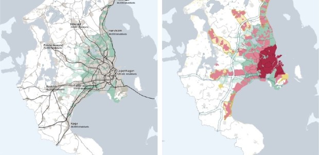
With about 1.3 million inhabitants, the Copenhagen metropolitan area (Greater Copenhagen) accounts for about 22% of Denmark's population and concentrates a large part of the country's economic activities in a constrained territorial area.12 However, due to the region’s density, a substantial portion of the metropolitan population resides in peri-urban areas. This increases the number of commuting journeys between home and work, while also contributing to land artificialisation.
In 1947, the city of Copenhagen adopted an urban development strategy called “the Finger Plan” as a strategy for the development of the Copenhagen metropolitan area. The plan takes its name from the hand-like shape of the proposed development pattern (Figure 3.5). The ‘palm’ represents the historic city centre, from which five urban corridors, symbolising the fingers, extend outward. Each corridor identifies areas designated for urban development, while the spaces between the ‘fingers’ are reserved as green areas, preserved for nature and public accessibility. The Finger Plan enabled the city to expand while protecting natural landscapes. It also reflected a post-war understanding that urban regeneration within the city needed to be complemented by managed outward growth. The plan was rooted in a clear commitment to avoiding unregulated suburban sprawl.

Source: Demain la Ville, at: https://www.demainlaville.com/content/uploads/2020/09/copenhague-finger-plan-ministry-of-the-environment-denmark-2015.jpg accessed on 21 February 2025.
The Finger Plan recognised that, while many people wished to move out of the overcrowded city for residential purposes, they would still need to travel back into the city for work and to access various urban opportunities. A decisive step in the implementation of the Plan was the construction of five S-train lines, around which new housing, along with associated business and service functions, would be clustered to form small urban centres. The foundation of the network was the two existing suburban railway lines radiating from the city. One of the unique aspects of the Plan, beyond preserving green corridors in peri-urban areas, was its deliberate encouragement of public transport use, particularly trains, over private car use.
Since its inception, the Finger Plan has evolved through several iterations, each formalised as a national directive. Local communities affected by the Plan are legally required to comply with it. The national government designates areas available for urban development, while local authorities are responsible for enforcing the policy. In its most recent version, adopted in 2007, the Plan stipulates that all office buildings with more than 1 500 m² of floor space must be located within a 600-metre walking distance of a train station. This distance was chosen because it effectively promotes train use for commuting and can potentially reduce car usage by up to 50% among suburban residents. The same principle applies to residential development: housing cannot be constructed beyond 1 kilometre on either side of a railway line or station. As a result, urban development is restricted to a maximum width of 2 kilometres along each ‘finger’. The Finger Plan also reflects the evolving housing needs of the population. It not only anticipated population growth but also responded to demand for higher-quality housing alternatives to overcrowded city apartments lacking basic amenities.
Research suggests that the Finger Plan has been effective in preventing urban sprawl and avoiding the development of chaotic, congested urban landscapes associated with lower quality of life (Sørensen and Torfing, 2019[20]). Part of the success of the Plan has been that it not only controls rapid urbanisation while promoting efficient transport and preserving nature for recreational use, but also interlinks different urban functions in ways that create synergies rather than negative externalities.
At the time of its elaboration, the Plan was considered visionary, bold, and highly ambitious due to its rational and comprehensive approach to urban planning. It gained early support from a broad political coalition that included planning professionals, local and regional governments, and several national ministries—each with their own priorities. For instance, planners were motivated by professional standards for systematic, evidence-based planning, while the 30 municipalities within Greater Copenhagen recognised the necessity of coordinating their local efforts (Sørensen and Torfing, 2019[20]). Moreover, the Finger Plan was elaborated by a group of professional planners who took the initiative. Then, the traditional system of top-down government gave way to a system of collaborative governance that combined professional planning expertise with political strategizing and citizens buy-in. While planners played a pivotal role in initiating this multi-level governance model, formal government institutions eventually assumed a central role—both as participants in collaborative networks and as meta-governors who steered the planning process and worked to align diverse interests.
Despite its many achievements, the Finger Plan has not been able to anticipate all the changes that have affected the region. For example, the widespread availability of affordable private vehicles in the 1950s led to a significant increase in car ownership and use. Shifts in housing demand and family structures—such as more individuals living alone or couples delaying family formation, have created the need for new types of housing tailored to early adulthood. Additionally, the construction of the Øresund Bridge and the resulting daily commuting between Denmark and Sweden were not anticipated in the original plan. The development of suburban rail lines and motorways has also spurred growth beyond the inner city. These transformations now call for a reconfiguration of the Finger Plan to better reflect the expanded functional metropolitan area, which increasingly includes not only Greater Copenhagen but also Malmö and its surrounding region.13
What lessons for Korea?
The Finger Plan offers several valuable lessons that could be relevant to Korea:
Timing matters. The Plan underscores the importance of identifying windows of opportunity for introducing reforms or strategic plans, particularly during periods of revitalisation and regeneration following a crisis. Policy instruments may gain broader public acceptance when framed as part of a national recovery debate. This can be crucial for ensuring the long-term sustainability of a plan.
Policy complementarities are essential. The Finger Plan demonstrates the value of creating synergies between different urban functions. In Copenhagen, this was achieved by replacing traditional, layered city expansion with a radial development model, in which functions are integrated side by side along 'fingers' of growth. This highlights the importance of reviewing existing policy measures and identifying additional interventions that can reinforce or enhance these synergies.
Flexible transport strategies. The Plan suggests that transport goals can often be achieved through regulatory tools tailored to local contexts. For instance, regulations that promote housing construction along transport corridors can encourage compact, connected development. This is particularly relevant in Korea’s context of a shrinking population. However, the success of such measures requires strong political commitment at both national and subnational levels.
The principle of ‘station proximity’. A key concept in the Finger Plan is the clustering of housing, commercial, and service functions around transit nodes—specifically along radial rail and road lines. This approach enhances accessibility and supports transit-oriented development.
Integrating greening strategies into TOD. The Plan also highlights the benefits of combining transit-oriented development with urban greening policies. In the context of climate change, increasing green spaces can help mitigate air pollution and the effects of heatwaves. These areas provide opportunities for interaction with nature and improve mental and physical health, especially for children and older adults. However, planners must consider the potential for rising real estate values in areas with high-quality green infrastructure, which could affect affordability.
Balanced governance. The Finger Plan exemplifies a hybrid approach, combining bottom-up and top-down planning. It was initiated by professional planners and later supported by a coalition of politicians and citizens. This illustrates the importance of both political endorsement and citizen engagement for the successful implementation of long-term planning strategies.
Incorporating foresight into planning. While it is impossible to predict every future development, the Plan shows that incorporating foresight—through scenario-building based on internal and external drivers of change—can help regions adapt to evolving circumstances.
Encouraging compact liveable growth in Cork City (Ireland)
In 2022, Cork City had a population of over 224 000 inhabitants. As an emerging national hub of economic and urban growth, the city has been designated for substantial additional development over the next 20 years under Project Ireland 2040—a national policy framework outlining the government's long-term investment and planning priorities (Government of Ireland, n.d.[21]). Despite this potential, Cork City, like much of Ireland, faces challenges such as depopulation, an ageing population, and the need to boost economic resilience. In response, the city government adopted the Cork City Development Plan 2022–2028, which outlines how the city will grow and evolve over the six-year period, while also aligning with the broader Cork City 2040 Vision (Cork City Council, 2022[22]). This statutory plan covers not only Cork City but also the towns of Ballincollig, Blarney, Tower, and Glanmire, along with their wider hinterland areas.
The Plan seeks to support the Cork City 2040 Vision. The 2040 Concept Plan sets out the longer-term vision for land use planning and management in the city. It identifies areas for additional growth beyond the plan period within the city. The Pla has three key features:
It prioritises compact liveable growth to promote development at the right locations primarily through regeneration, consolidation and re-intensification. For the City Centre, the Plan seeks the regeneration and expansion of residential, employment, cultural and community uses to increase vibrancy in central neighbourhoods and decrease underutilised buildings and sites. A mix of uses, densities and high-quality design are expected to protect the amenities and character of a neighbourhoods. The Plan emphasises the regeneration of City Docks and Tivoli Docks along with other brownfield sites to deliver compact liveable growth by 2040.
It promotes TOD through the planning and delivery of Light-Rail Transit and its interaction with the Lee to Sea Greenway, suburban rail network, orbital bus routes and strategic bus corridors in key areas such as Blackpool, Ballyvolane, Mahon and South Ballincollig. The Cork Metropolitan Area Transport Strategy 2040 (CMATS) sets out the phased delivery of this new network designed to deliver an integrated multimodal city transport system. Longer term strategic planning and delivery of growth in areas such as Tramore Road, Stoneview and the lands located between the City and Ballincollig are expected to enhance the delivery of growth in Cork City and align with the National Planning targets up to 2040. Figure 3. shows the concept plan for Cork City in 2040 that depicts a vision for land use planning identifying areas of growth along a transport corridor.

Source: Cork City Council, at: https://storymaps.arcgis.com/stories/e6d297d107fa44249c1010cf2390320e, accessed on 21 February 2025.
It seeks employment-led growth as it is estimated that approximately 35 000 new jobs will be generated by the planned population growth. Lands have been zoned to accommodate future demand while targeting neighbourhoods where there are relatively high levels of unemployment, creating inclusive and sustainable communities and anticipating likely market trends over the period to 2028 (Cork City Council, 2022[22]).
A City Capacity Study was conducted to assess the potential for future development at the site level, focusing on underutilised zoned lands such as brownfield, infill, and greenfield sites. The study supported local authorities in identifying infrastructure weaknesses and gaps across different areas of the city. It also informed evaluations of how best to accommodate new development within, and adjacent to, the existing built-up area of the city.14
The Development Plan sets out nine strategic objectives linked to the overarching roles of the UN Sustainable Development Goals (SDGs).
Compact liveable growth
Delivering homes and communities
Transport and mobility
Climate and environment
Green and blue infrastructure, open space and biodiversity
Economy and employment
Heritage, tourism and arts
Environmental infrastructure
Placemaking and managing development (Cork City Council, 2022[22]).
The core strategy focuses on objectives that deliver compact liveable growth within the city. Given their nature, delivering the strategic objectives requires the joint efforts of Cork City Council, residents, a wide range of stakeholders, developers, local government departments, and State and local development agencies.
What lessons for Korea?
Encouraging compact liveable growth in Cork City is an ongoing effort, but it has some lessons that may be useful for Korean cities as they share the challenge of promoting compact development in the context of demographic change.
It highlights the importance of strategic planning and the adoption of a proactive land use management approach, grounded in a clear vision of how the city is expected to grow and evolve.
It underscores the need to include neighbouring areas in strategic planning, recognising the interdependencies between the urban core and surrounding communities.
It emphasises the necessity of implementing an urban regeneration and revitalisation strategy for central areas, given their economic significance.
It stresses the value of a transport-oriented approach, promoting the development of an integrated multimodal transport system that connects the city centre with nearby areas to improve accessibility.
It applies the Sustainable Development Goals (SDGs) as a framework to guide the compact, liveable growth strategy, helping to link diverse policy areas that contribute to sustainable urban development.
References
[9] Christeller, R. (2020), Paris invests massively in urban rail and unveils Grand Paris Express metro mock-up, https://www.urban-transport-magazine.com/en/paris-invests-massively-in-urban-rail-and-unveils-grand-paris-express-metro-mock-up/.
[19] City of Vancouver (2025), Jericho Lands takes next steps with Official Development Plan, https://vancouver.ca/news-calendar/jericho-lands-next-steps-official-development-plan-april-2025.aspx (accessed on 6 May 2025).
[22] Cork City Council (2022), Cork City Development Plan, https://www.corkcity.ie/en/cork-city-development-plan/ (accessed on 18 November 2024).
[21] Government of Ireland (n.d.), Project Ireland 2040. Building Ireland’s Future, https://assets.gov.ie/7335/7692660a70b143cd92b1c65ee892b05c.pdf (accessed on 18 November 2024).
[4] Huang, J. et al. (2024), “Livability-oriented urban built environment: What kind of built environment can increase the housing prices?”, Journal of Urban Management, Vol. 13/3, https://doi.org/10.1016/j.jum.2024.04.001.
[17] Huerta Melchor, O. and A. Lembcke (2020), Developing transit-oriented communities for better accessibility and affordability: The case of the Metro Vancouver Region, OECD Publishing, Paris, https://doi.org/10.1787/267a6231-en.
[14] Krawchenko, T. (2012), Institutional solutions to jurisdictional fragmentation: the implications of regional special purpose bodies for how city-regions are governed in Canada, Carleton University, Ottawa, https://curve.carleton.ca/system/files/etd/e7394189-ce9c-4ab8-8639-0e8d4757f3cc/etd_pdf/f61957f28474c73272213bd880d940b6/krawchenko-institutionalsolutionstojurisdictionalfragmentation.pdf.
[11] Mori, M. (2013), Toyama’s unique compact city management strategy: creating a compact city by re-imagining and restructuring public transportation, United Nations Centre for Regional Development, https://uncrd.un.org/sites/uncrd.un.org//files/7th-est_keynote2.pdf.
[7] NSW Government (2024), State Significant Development Guidelines, https://www.planning.nsw.gov.au/sites/default/files/2023-03/state-significant-development-guidelines.pdf.
[6] NSW Government (2023), Transport Oriented Development Program, https://www.planning.nsw.gov.au/policy-and-legislation/housing/transport-oriented-development-program.
[2] OECD (2020), City Policy Responses, OECD , Paris, https://read.oecd-ilibrary.org/view/?ref=126_126769-yen45847kf&title=Coronavirus-COVID-19-Cities-Policy-Responses.
[8] OECD (2018), Housing Dynamics in Korea: Building Inclusive and Smart Cities, OECD Publishing, Paris, https://doi.org/10.1787/9789264298880-en.
[12] OECD (2012), Compact City Policies: a comparative assessment, OECD Publishing, https://doi.org/10.1787/9789264167865-en.
[13] Paul, K. et al. (2021), Toyama City Compact City Development (English)., https://documents.worldbank.org/en/publication/documents-reports/documentdetail/113011604996380368/toyama-city-compact-city-development.
[1] Rode, P. et al. (2014), “Accessibility in Cities: Transport and Urban Form”, No. NCE Cities Paper 03, LSE Cities, London School of Economics and Political Science, http://www.lsecities.net (accessed on 9 July 2019).
[5] Rode, P. et al. (2019), National Transport Policy and Cities: Key policy interventions to drive compact and connected urban growth, Coalition for Urban Transitions, London and Washington, http://www.coalitionforurbantransitions.org (accessed on 2 October 2020).
[3] Rode, P. et al. (2021), Better Access to Urban Opportunities: Accessibility Policy for Cities in the 2020s, Coalition for Urban Transitions, London and Washington, D.C., https://urbantransitions.global/publications (accessed on 9 December 2021).
[10] Société du Grand Paris (n.d.), Grand Paris Express. A metro for the 21st century, https://media-mediatheque.sgp.fr/medias/domain12814/media500/75363-ygdyu0bx2n.pdf (accessed on 4 November 2024).
[20] Sørensen, E. and T. Torfing (2019), The Copenhagen Metropolitan ‘Finger Plan’: A Robust Urban Planning Success Based on Collaborative Governance, Oxford University Press, https://doi.org/10.1093/oso/9780198843719.003.0012.
[18] TransLink (2025), Broadway Subway Project, https://www.translink.ca/plans-and-projects/projects/rapid-transit-projects/broadway-subway-project (accessed on 6 May 2025).
[16] TransLink (2023), Transit Service Performance Review 2023, https://www.translink.ca/-/media/translink/documents/plans-and-projects/managing-the-transit-network/tspr/2023_transit_service_performance_review.pdf (accessed on 6 May 2025).
[15] TransLink (2012), Transit-Oriented Communities Design Guidelines Creating more livable places around transit in Metro Vancouver, https://www.translink.ca/-/media/translink/documents/plans-and-projects/managing-the-transit-network/transit-oriented-communities/transit_oriented_communities_design_guidelines.pdf (accessed on 28 August 2018).
← 1. See: https://www.planning.nsw.gov.au/policy-and-legislation/housing/transport-oriented-development-program/transport-oriented-development#frequently-asked-questions
← 2. For further information see: Special entertainment precincts: https://www.planning.nsw.gov.au/policy-and-legislation/night-time-economy/special-entertainment-precincts
← 3. For further information see: https://www.agglo-pvm.fr/actions-et-projets/transports/grand-paris-express
← 10. For further information see: Profile table, Census Profile, 2021 Census of Population - Vancouver, City (CY) at: https://www12.statcan.gc.ca/census-recensement/2021/dp-pd/prof/details/page.cfm?Lang=E&SearchText=Vancouver&GENDERlist=1&STATISTIClist=1&DGUIDlist=2021A00055915022&HEADERlist=0 and /www.macrotrends.net/global-metrics/cities/20404/vancouver/population
← 11. For further information see: https://www.translink.ca/plans-and-projects/strategies-plans-and-guidelines/project-partnership-agreements#supportive-policies-agreements
← 14. For further information see: https://storymaps.arcgis.com/stories/e6d297d107fa44249c1010cf2390320e